Land Registry Drawings
Accurate, compliant land registry drawings that simplify property transactions and boundary clarity.
Land Registry Drawings
At M2 Consulting, we specialise in producing land registry compliant drawings that are accurate, reliable, and tailored to the needs of each client. Whether for property transactions, lease agreements, development projects, or boundary clarifications, our plans are prepared to meet strict land registry standards, ensuring a smooth and stress-free process.
We work closely with homeowners, solicitors, developers, and property professionals, combining technical expertise with a personal approach that makes complex requirements straightforward. Our goal is simple: to deliver precise drawings that you can trust, backed by clear communication and dedicated support from start to finish.
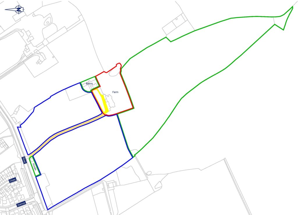
Examples of Land Registry Drawings
Title Plans – showing the legal boundaries of a registered property.
Lease Plans – for leasehold properties, detailing the demised premises (with location plan, floor plan, and any shared/common areas).
Transfer Plans – illustrating land being transferred or sold from a larger title.
Boundary Plans – clarifying disputed or uncertain property boundaries.
Subdivision Plans – when dividing a larger parcel of land into smaller plots.
Conveyance Plans – supporting property sales or transfers with clear boundary mapping.
Easement Plans – defining rights of way, access routes, or shared service areas.
Land Assembly Plans – combining multiple parcels into one registered title.

Do you need a land registry drawing?
Contact us to discuss how we can assist.
Requirement of Land Registry Compliant Drawing
General Requirements
- Drawn to scale – must be at a recognised metric scale (e.g. 1:1250, 1:2500 for site plans; 1:100 or 1:200 for building/lease plans).
- Scale bar included – so the plan can still be understood if printed or copied at a different size.
- North point shown – for orientation.
- Clear and legible – black/blue ink for boundaries, red for site outlines; no faint, coloured shading that won’t reproduce clearly.
- A4 size preferred – but A3 accepted if necessary.
Boundary & Site Detail
- Exact boundaries clearly defined – the land or property must be edged in red.
- Other land in applicant’s ownership – edged in blue.
- Rights of way / easements – clearly shown and labelled.
- Measurements – included if necessary for clarity (e.g. building outlines, parking spaces).
Mapping & Context
- Base map detail – should show sufficient surrounding features (roads, neighbouring plots, landmarks) for identification.
- OS mapping or equivalent – plans must be based on accurate mapping data, not freehand sketches.
- No ambiguity – plans must not overlap, leave gaps, or rely on vague features (like “to the hedge”).
Lease / Flat Plans (extra rules)
- Floor level identified – clearly showing the floor within a multi-storey building.
- Communal areas shown – such as shared stairwells, car parks, or access routes.
- Extent of leasehold property edged in red – with shared areas marked differently (often tinted or hatched).
